We Are Better Together
Our Commercial Innovation Center (CIC) is a first-of-its-kind, online development and test platform that provides a secure, virtual, open ecosystem and test sandbox for developers and researchers. We do it by harnessing the combined powers of commercial remote sensing, unclassified open datasets, cloud technologies, in a secure development ecosystem fueled by new, emerging, and seasoned tools, services and data to create solutions that keep our nation safe. The Riverside Research CIC is the place where commercial subject matter experts come together securely to collaborate and create the best commercial solutions to real world scenarios before they're integrated and deployed in the field.
Together, we win
It’s not as much fun to play in the sandbox by yourself, right? We know from experience that it’s the collective work of many people with diverse experiences and backgrounds that create the most effective solutions. By design, the CIC encourages partnerships, increases data accessibility, integrates app development, and facilitates the creation of transition-ready prototypes. Because of our unique position as a nonprofit in the defense space, we can provide the neutral environment where collaborative innovation thrives. As demonstrated on this video, capitalizing on all commercial sensors available improves our progress towards persistent observation.
Access to rich datasets
Data is the one thing that is guaranteed to continuously grow and change. Technology entrepreneurs’ success revolves around access to these data and developing improved AI and machine learning tools creating integrated and advanced applications for businesses in support of (United States Government) USG needs.
Advanced tools and applications
Technology innovation in artificial intelligence, machine learning, and augmented and virtual reality present significant entrepreneurial opportunities, yet all require geospatial data for development. Early-stage entrepreneurs, academic researchers, and innovators will now have access to the large datasets that are traditionally only available to large, established industry players. Such datasets are often too costly for early-stage entrepreneurs and researchers to acquire, and even if the datasets are made available, they are often not packaged in a manner that allows innovators to work with the data—they are overwhelmingly unwieldy and non-standardized. The CIC data environment seeks to solve that problem, allowing researchers and entrepreneurs new opportunities for experimentation, testing, and training.
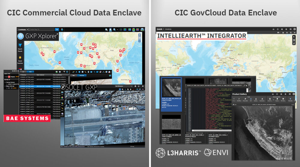
The CIC pairs this data with tools and services to streamline development timelines by ensuring flexible licenses are available for your R&D activities within the CIC ecosystem. As new tools and services become available, we negotiate with the vendors for early and shared access amongst our CIC participants to the latest and greatest capabilities from established vendors in the remote sensing market. This visual shows a few or our early integrators, and as new vendors are integrated, we’ll let the community know!
Your all-access pass
The CIC supports and enables industry, scientific, academic, and governmental R&D activities by facilitating access to commercial remote sensing data. Riverside Research integrates the hardware, software, processes, data, tools, internet accesses, demonstration capabilities, and other IT infrastructure required to execute CIC participant SIBR projects and meet R&D objectives. Our CIC offers:
- Exposure to diverse and emerging data and data types for more data scientists
- Increased interaction between content providers and new application developers; enables cloud-hybrid, multi-INT applications
- Lowered entry barriers by eliminating the need for a user-developed system
- Integrated orchestration-to-analysis workflow
- Timely teaming, technology, and tipping
- Accelerated access and use of commercial remote sensing solutions and innovation
Right where you want it
Are you looking for a cloud-hosting environment where you can easily access commercial data for development and test—all from one place to safely develop, load, and test capabilities?
Our trusted, unclassified, virtual development platform provides access to R&D-licensed commercial remote sensing phenomenologies (e.g., EO, radar, IR, RF), connects emerging and established vendors with shared application tools and services, and facilitates GEOINT, MASINT, and Multi-INT research and development. The CIC includes:
- An ecosystem of commercial data providers (CDPs)
- A network of application developers
- Common R&D data and COTS/GOTS tools (e.g., loading, discovery)
- Common testing data (curated, tagged)
- Robust DevOps environment
- Hybrid cloud-ready infrastructure
- Protected intellectual property and data rights
- Maturing secure data fabric
CIC mission, vision & values
Mission: Provide data scientists and algorithm developers with a virtual development and test platform and access to new and diverse commercial remote sensing data to develop algorithms, tools, and services.
Vision: Work in the Nation’s interest to offer proven expertise and experience in commercial remote sensing to solve problems through innovation, agility, and creative thinking.
Values: Encourage partnerships and connect emerging and established users across USG and industry with shared application tools, services, and diverse commercial constellation data.

Participant Agreements: We offer access to a secure, virtual, cloud-based ecosystem to perform R&D using existing and emerging commercial sources to develop and test algorithms, tools, and services accelerating USG objectives.
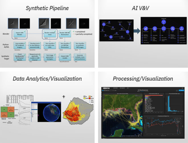
Commercial Experts: We offer our commercial experience, data scientists, and phenomenology experts to support efforts using the CIC to perform commercial utility assessments, new sensor development, synthetic data V&V, data value/usability studies, and more.
Products and Services: We offer access to CIC-based products and services such as synthetic data generation, data tagging, AI/ML V&V, data compression, data geo-registration, and more.
Work With the Commercial Innovation Center
Press Inquiries About the CIC
Commercial Innovation in the News
- Commercial Imagery
- Satellite Launches
- EO-MSI
- SAR
- HSI
- RF
- SSA
Commercial Imagery
SatVu to expand thermal imaging constellation with NATO-backed funds - SpaceNews
“We have a clear and credible path to a multi-satellite constellation, accompanied by investors that match the ambition and pace of the business.”.
Protecting the world's most critical energy region with AI satellite analysis
How does AI fit in? Geospatial analytics is the analysis of satellite imagery, and is fundamentally, a high-tech method of identifying problem points ...
Satellite imagery and AI reveal development needs hidden by national data
Researchers trained a machine learning model on satellite images of states and provinces alongside survey-based data from each country. (Image ...
What's geologic hydrogen? What to know about the clean energy source buried under Michigan.
Research shows the state may be a hotspot for the resource, prompting a scramble to understand its potential. Satellite ... Science. Satellite image of ...
Digital forestry team combines AI with satellite data to monitor urban trees
Satellite image of individual trees in Indianapolis, Indiana. These images were generated by a team at Purdue's Institute for Digital Forestry to ...
Meeting Tomorrow For 1532 Mount Diablo Boulevard, Walnut Creek - San Francisco YIMBY
... 1532-1556 Mount Diablo Boulevard, image via Google Satellite. The meeting is scheduled to start tomorrow, February 18th ...
BlackSky signs eight-figure international deal for accelerated delivery of Gen-3 sovereign ...
BlackSky signs eight-figure international deal for accelerated delivery of Gen-3 sovereign intelligence satellite ... BlackSky Technology Inc. has ...
UK thermal intelligence startup SatVu secures €34 million to scale multi-satellite constellation
... satellite demonstration to execution of a multi-satellite constellation. ... intelligence they cannot access elsewhere. High-resolution thermal ...
UK thermal intelligence firm SatVu raises £30M to scale multi-satellite thermal constellation
The firm plans to expand its thermal satellite constellation and scale activity intelligence.
OroraTech Appoints Distributed Satellite Pioneer Ignacio Zuleta as CTPO to Lead the Next ...
OroraTech Appoints Distributed Satellite Pioneer Ignacio Zuleta as CTPO to Lead the Next Era of Global Thermal Intelligence. Oops, something went ...
Worst of the storms is about to hit SF Here's when to expect downpours and hail showers
Infrared satellite imagery captured cold clouds taking a direct path from the Gulf of Alaska toward the West Cost on Monday. Baron/Lynx. Wind gusts of ...
New guidance for documenting war's impact on nature - CEOBS
Satellite image analysis revealed Russian or Belarusian military earthworks (fortifications, trenches, bunkers, etc.) at 33 locations. Another ...
US & Israel On Alert? How China Pivot Made Iran's Missile & Drone Arsenal Deadlier After 2025 War
Chinese satellite imagery and expanded space-based coordination are now seen as key components of Iran's evolving “kill chain.” Here's a breakdown ...
SatVu lands £30M including NATO backing to scale thermal satellite constellation
Fresh funding will help the thermal imaging specialist observation firm grow its heat-sensing satellite fleet and ramp up operations. Carly Page by ...
WRC-27 Agenda Item 7: A pathway to improving satellite regulations | SES
WRC-27 Agenda Item 7: A pathway to improving satellite regulations. SES-Blog-WRC-27-banner-image ... satellite regulation. The primary focus of this ...
U.S. Carrier Strike Group Positions 700 km from Iran
... satellite an image of the U.S. Navy's Abraham Lincoln aircraft carrier. /AFP-Yonhap. As the United States intensifies military and diplomatic ...
Global high-resolution estimates of the UN Human Development Index using satellite ...
The combination of satellite imagery and machine learning (SIML) is increasingly used to predict socioeconomic variables at fine spatial resolution10, ...
Fayil:Amazon fire satellite image.png - Wikipedia
English: Amazon fires 15-22 August 2019. satellite image taken by MODIS. Rana, 22 Agusta 2019. Masomi, https://www.earthobservatory.nasa.gov/ ...
Global 0.05° Grid-Based Dataset of Keyhole Imagery with Spatio-Temporal Indicators (1960–1984)
The American satellite reconnaissance program (Keyhole imagery) is serving as a significant data source for geoscience research because of its ...
SatVu Secures £30M in Funding with NATO Innovation Fund Backing - IndexBox
British company SatVu raises £30 million, backed by the NATO Innovation Fund, to expand its high-resolution thermal imaging satellite technology ...
Satellite Launches
Which countries are actually serious about developing their own rockets? - Ars Technica
... launch their satellites on European rockets, but that's not always possible. ESA and the EU launched several key satellite missions on SpaceX ...
SatVu to expand thermal imaging constellation with NATO-backed funds - SpaceNews
SpaceX was previously lined up to launch SatVu's HotSat-2 and HotSat-3 satellites, both built by U.K.-based Surrey Satellite Technology Ltd. (SSTL), ...
Spexi Orthomosaic Drone Imagery Now Available on SkyWatch Platform - Dronelife
With the launch, SkyWatch customers can access Spexi's stitched, orthorectified imagery over 38 cities across North America. Each dataset supports ...
China's 09V sub signals shift in Pacific's undersea power - Asia Times
... launch bay at the Bohai Shipbuilding Heavy Industry yard in Huludao, satellite and radar imagery show, marking a significant milestone in the ...
Watch Time-Lapse Of LARES-2 Satellite In Orbit On Vega C Rocket's Upper Stage - Dailymotion
Imagery Of M87's Black Hole Shows Polarity Flip - ESO Explains · Space ... Blue Origin Deploys Amazing Free Flying Camera During New Shepard Launch.
US Air Force Sentry surveillance jets tracked from Alaska to UK amid Iran tensions - BBC
... launch attacks against Iran. Yesterday we identified the US aircraft carrier USS Abraham Lincoln in satellite imagery off the coast of Oman. Now ...
Spexi Orthomosaic Drone Imagery Now Available on the SkyWatch Platform | Newswire
With this initial launch, SkyWatch users can access Spexi's ... satellite, aerial, and now standardized drone imagery through a single ...
Treefera Launches Market Intelligence for Ag & Soft Commodities – Delivering Earlier Yield ...
Through proprietary science and advanced AI modelling, Treefera synthesizes satellite imagery, environmental signals and field-level data into ...
Sateliot Selects PLD Space to Launch Two 5G Direct-to-Device Satellites
Spain's Sateliot has selected PLD Space to launch two 5G D2D satellites aboard a dedicated MIURA 5 flight in 2027.
Earth Observation Data Provider SatVu Closes £30 Million Funding Round
... imagery with a resolution of up to 3.5 metres. ... At the time, the company stated that the two satellites were scheduled for launch in 2025, but they ...
Russian Offensive Campaign Assessment, February 16, 2026 - Institute for the Study of War
... launch site in Astrakhan Oblast in January 2025. A Ukrainian open ... satellite imagery and other geospatial data as the basis for these reports.
Satellite Images Reveal China's New Type 095 Nuclear Attack Submarine
Commercial satellite imagery captured on 9 February 2026 indicates that China may have launched its first next-generation Type 095 nuclear-powered ...
OroraTech's New Exec Plans to Step on the Gas - Payload Space
... satellite agreements to meet the demand. While OroraTech owns and operates its own satellites, it has also flown its thermal sensing hardware as ...
Middle East and North Africa Satellite Imagery (MENA) Market - openPR.com
✓ February 2025: UAE Space Agency launched advanced Earth observation satellites to enhance climate monitoring and urban planning. ✓ July 2025: Saudi ...
About 100 Aircraft, Including Su-34 and Su-35 Jets, Spotted at Airbase in Lipetsk
... Syrskyi: Ukrainian ... In particular, one MiG-31 has no longer appeared in satellite imagery ...
Orbex releases unseen images of Prime assembly - ADS Advance
... launches of Orbex's microlauncher Prime were due to take place later this year. Orbex had commercial launch commitments from several satellite ...
Sateliot, PLD Space to launch two 5G satellites in first Spanish mission | Reuters
Satellite startup Sateliot and space engineering firm PLD Space have signed a deal to launch two 5G satellites in what will be the first such ...
US & Israel On Alert? How China Pivot Made Iran's Missile & Drone Arsenal Deadlier After 2025 War
Chinese satellite imagery and expanded space-based coordination are now ... Iran Launches 'Lockdown' Of Key Oil Route Hormuz Strait, Shocks ...
Satellite images show Trump's US aircraft carrier miles off Oman coast - The US Sun
CALL THIS PEACE? Nato scrambles jets over Russian blitz launched hours before peace talks – as Trump demands Ukraine 'come to the table' ...
Orbex collapse fails to halt progress for UK domestic launch capability
The European small satellite launch sector has suffered a setback with ... Images showed integrated second stage and fairing structures, with ...
EO-MSI
Stocks Flashing Renewed Technical Strength: BlackSky Technology
The company earns the No. 6 rank among its peers in the Telecom Services-Cable/Satellite industry group. Planet Labs PBC (PL), Comcast Cl A (CMCSA) ...
AI transforming farming, says Maha official; cites smart cow necklaces, satellite sugar tests
On soil testing, she said portable devices under the Vasudha and Neo Park programmes use hyperspectral imaging to deliver a complete soil chemical ...
Ukrainian drone maker Skyeton integrates satellite communications into Raybird UAS to ...
BlackSky signs eight-figure international ...
Digital forestry team combines AI with satellite data to monitor urban trees
And because the data they use from the PlanetScope constellation of 130 satellites includes 15 years of historical records, the system can ...
Blacksky Technology Inc. Signs New Eight-Figure International Contract for Accelerated ...
Once operational, the Gen-3 satellite will work in parallel to BlackSky's constellation to deliver mission-relevant insights at speeds. Gen-3's ...
BlackSky (BKSY) Secures Major Contract for Gen-3 Space Intelligence Solution - GuruFocus
Key Takeaways: BlackSky Technology (BKSY) secures a major international contract for its Gen-3 satellite technology.
BlackSky signs eight-figure international deal for accelerated delivery of Gen-3 sovereign ...
The agreement includes the sale of one Gen-3 very-high resolution 35-centimeter satellite along with recurring, multi-year on-orbit operations and ...
BlackSky Signs New Eight-Figure International Contract for Accelerated Delivery of Gen-3 ...
BlackSky possesses proprietary in-house satellite design and agile manufacturing, constellation operations and end-to-end advanced software ...
OroraTech's New Exec Plans to Step on the Gas - Payload Space
Ignacio Zuleta—who has spent over a decade working for, or advising, EO firms including Planet Labs, Satellogic, and Hydrosat—was appointed as ...
Middle East and North Africa Satellite Imagery (MENA) Market - openPR.com
... satellite providers to enhance border surveillance and environmental mapping using high-definition imagery. Major Top Key Players: BlackSky ...
Ukraine War, Day 1,454: Kyiv Regains Territory in South After Russia's Troops Lose Starlink
Subscribe to our email list to receive a weekly selection of stories published by EA WorldView during the previous week. Success! Email.
Lean into the ride on the open road or closed track with zūmo XT3 from Garmin | Morningstar
... Satellite imagery © 2026 Maxar Technologies (date of satellite imagery may vary). The Bluetooth word mark and logos are registered trademarks ...
Satellite images show growing Russian fighter jet 'boneyard' at Lipetsk Air Base
The Su-34, in particular, is doing much of the work in the war in Ukraine. There are very interesting things visible in the Maxar sat imagery of ...
SatService to supply Q V band satcom ground station for Bundeswehr university
Berlin, Germany (SPX) Feb 17, 2026 - SatService GmbH, a Germany based provider of advanced satellite ... BlackSky expands Gen 3 Assured deals with new ...
BlackSky expands Gen-3 assured access for international defense customer - Space War
BlackSky is leveraging a vertically integrated technology stack that combines satellite manufacturing, software and AI driven analytics to meet ...
BlackSky Secures Another Seven-Figure Contract - The Journal of Space Commerce
Assured provides early intelligence, surveillance and reconnaissance capabilities for the customer until their satellite systems enter operation. Once ...
Cuba is dimming: satellite images show a 50% decrease in nighttime light - CiberCuba
... Team. Monday, February 16, 2026 - 4:08 PM. Cuba in the midst of an energy crisisPhoto © NASA Earthdata Worldview. Share on: Related videos: ...
National Earth's doppelganger: scientists make $15m digital twin - | Corowa Free Press
A Satellite Earth Station in WA (file image) Satellite images and ... 'Heart of gold': mum backs neo-Nazi fan after hate rant. A mother has ...
Data Products from Satellogic and Vantor Added to CSDA's Satellite Data Explorer | Mark Carmichael
Data Products from Satellogic and Vantor Added to CSDA's Satellite Data Explorer NASA's Commercial Satellite Data Acquisition (CSDA) Program ...
SAR
AAC Clyde Space Initiates Earth Observation Expansion | Aviation Week Network
Related Content. ymir satellite · AAC Clyde Space Expands Maritime Data Satellite Fleet · Iceye satellite images Stockholm · Sweden Joins Iceye SAR ...
ASII launches national geospatial digital twin for Australian agriculture - Space Daily
... PAZ satellite flying in constellation with the German TerraSAR-X and TanDEM-X missions. EARTH OBSERVATION · International crew takes off for space ...
Airbus taps Synspective SAR radar network for expanded Earth imaging - Space War
Paris, France (SPX) Feb 17, 2026 - Airbus Defence and Space has signed a new radar satellite ... TerraSAR-X, TanDEM-X and PAZ. The combined fleet is ...
Santa Barbara Satellite Company Umbra Expanding to Virginia | Local News | Noozhawk
A satellite manufacturing company launched in Santa Barbara will expand again, adding a large facility in Virginia. Umbra last week announced ...
PSLV-C62's fourth stage ignited before descent: Orbital Paradigm
The rocket carried India's strategic satellite EOS-N1 as primary passenger and 15 other small satellites belonging to Indian and foreign entities.
HSI
AI transforming farming, says Maha official; cites smart cow necklaces, satellite sugar tests
AI transforming farming, says Maha official; cites smart cow necklaces, satellite sugar tests ... Pixxel, Dhruva Space select Exotrail thrusters to ...
India and France Unite: Space-Tech Pioneers Launch Satellite Ventures - Devdiscourse
Pixxel Space and Dhruva Space collaborate with Exotrail, a French propulsion provider, to advance satellite tech.
Pixxel, Dhruva Space select Exotrail thrusters to steer satellites in orbit - Press Trust of India
According to the agreement, Pixxel will integrate Exotrail's "spaceware" electric propulsion systems across its upcoming satellite deployments, with ...
Northstar Extends Maturing Convertible Debentures - Stock Titan
... Satellite · All Stock Rankings Largest Companies by Market ... For further information about Northstar, please visit www.northstarcleantech.com.
Pixxel, Exotrail Partner to Power Earth Observation Satellites | Analytics India Magazine
Pixxel will deploy Exotrail's spaceware propulsion systems across future satellite launches through 2027.
Pixxel and Exotrail Announce Electric Propulsion Contract to Power Next-Generation Earth ...
The systems will support Pixxel's expanding Earth Observation constellation and broader space infrastructure roadmap. Pixxel's constellation is ...
Pixxel partners with Exotrail to boost satellite capabilities - NewsBytes
Space-tech startup Pixxel Space has partnered with French firm Exotrail to utilize its electric propulsion systems for steering Pixxel's advanced ...
Pixxel selects Exotrail thrusters to steer its satellites in orbit - The Economic Times
"Under this agreement, Pixxel will integrate Exotrail's spaceware electric propulsion systems across its upcoming satellite deployments, with ...
Sovereign AI Models Launched at AI Impact Summit - Rediff Money
Pixxel & Exotrail Partner for Satellite Thrusters. Pixxel selects Exotrail thrusters to steer its satellites in orbit. Partnership boosts ...
India's AI Revolution: Sovereign Models Set to Transform Digital Landscape - Devdiscourse
Pixxel Space Partners with French Firm to Propel Satellite Innovation ... satellite constellation and its overarching space infrastructure ambitions.
AI for Agriculture: Bridging the Information Gap - Rediff Money
MeitY Secretary S Krishnan calls for using AI to bridge the information gap in... Pixxel & Exotrail... Pixxel & Exotrail Partner for Satellite ...
Pixxel selects Exotrail thrusters to steer its satellites in orbit - Press Trust of India
New Delhi, Feb 17 (PTI) Space-tech startup Pixxel Space on Tuesday announced partnership with French electric propulsion provider Exotrail to ...
Pixxel Space Partners with French Firm to Propel Satellite Innovation - Devdiscourse
Pixxel Space has partnered with Exotrail, a French propulsion provider, to enhance its satellite capabilities. This collaboration will integrate ...
Exotrail Secures Landmark Propulsion Deals with Indian Space Firms - Devdiscourse
The contracts involve prominent Indian companies like Dhruva Space, a satellite manufacturer; Pixxel, a space infrastructure developer; and XDLINX ...
Exotrail Secures Landmark Propulsion Deals with Indian Space Firms - Devdiscourse
... Pixxel, and XDLINX Labs, significant ... The contracts involve prominent Indian companies like Dhruva Space, a satellite manufacturer; Pixxel ...
Topcon secures early access to Xona's Pulsar satellite navigation service - GPS World
... satellite navigation constellation. This agreement ... Modern Northstar: Starlink LEO PNT across land, air, stratosphere and Arctic Seas.