We Are Better Together
Our Commercial Innovation Center (CIC) is a first-of-its-kind, online development and test platform that provides a secure, virtual, open ecosystem and test sandbox for developers and researchers. We do it by harnessing the combined powers of commercial remote sensing, unclassified open datasets, cloud technologies, in a secure development ecosystem fueled by new, emerging, and seasoned tools, services and data to create solutions that keep our nation safe. The Riverside Research CIC is the place where commercial subject matter experts come together securely to collaborate and create the best commercial solutions to real world scenarios before they're integrated and deployed in the field.
Together, we win
It’s not as much fun to play in the sandbox by yourself, right? We know from experience that it’s the collective work of many people with diverse experiences and backgrounds that create the most effective solutions. By design, the CIC encourages partnerships, increases data accessibility, integrates app development, and facilitates the creation of transition-ready prototypes. Because of our unique position as a nonprofit in the defense space, we can provide the neutral environment where collaborative innovation thrives. As demonstrated on this video, capitalizing on all commercial sensors available improves our progress towards persistent observation.
Access to rich datasets
Data is the one thing that is guaranteed to continuously grow and change. Technology entrepreneurs’ success revolves around access to these data and developing improved AI and machine learning tools creating integrated and advanced applications for businesses in support of (United States Government) USG needs.
Advanced tools and applications
Technology innovation in artificial intelligence, machine learning, and augmented and virtual reality present significant entrepreneurial opportunities, yet all require geospatial data for development. Early-stage entrepreneurs, academic researchers, and innovators will now have access to the large datasets that are traditionally only available to large, established industry players. Such datasets are often too costly for early-stage entrepreneurs and researchers to acquire, and even if the datasets are made available, they are often not packaged in a manner that allows innovators to work with the data—they are overwhelmingly unwieldy and non-standardized. The CIC data environment seeks to solve that problem, allowing researchers and entrepreneurs new opportunities for experimentation, testing, and training.
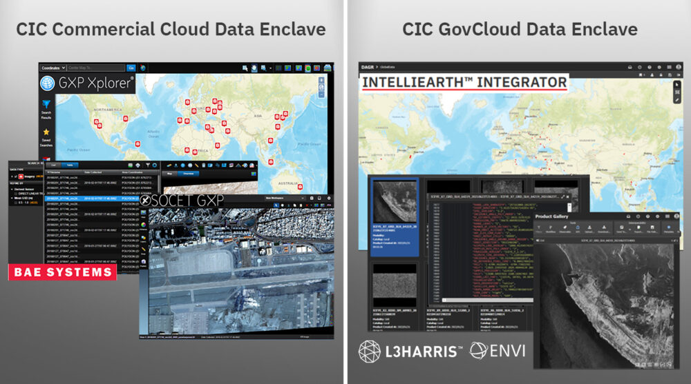
The CIC pairs this data with tools and services to streamline development timelines by ensuring flexible licenses are available for your R&D activities within the CIC ecosystem. As new tools and services become available, we negotiate with the vendors for early and shared access amongst our CIC participants to the latest and greatest capabilities from established vendors in the remote sensing market. This visual shows a few or our early integrators, and as new vendors are integrated, we’ll let the community know!
Your all-access pass
The CIC supports and enables industry, scientific, academic, and governmental R&D activities by facilitating access to commercial remote sensing data. Riverside Research integrates the hardware, software, processes, data, tools, internet accesses, demonstration capabilities, and other IT infrastructure required to execute CIC participant SIBR projects and meet R&D objectives. Our CIC offers:
- Exposure to diverse and emerging data and data types for more data scientists
- Increased interaction between content providers and new application developers; enables cloud-hybrid, multi-INT applications
- Lowered entry barriers by eliminating the need for a user-developed system
- Integrated orchestration-to-analysis workflow
- Timely teaming, technology, and tipping
- Accelerated access and use of commercial remote sensing solutions and innovation
Right where you want it
Are you looking for a cloud-hosting environment where you can easily access commercial data for development and test—all from one place to safely develop, load, and test capabilities?
Our trusted, unclassified, virtual development platform provides access to R&D-licensed commercial remote sensing phenomenologies (e.g., EO, radar, IR, RF), connects emerging and established vendors with shared application tools and services, and facilitates GEOINT, MASINT, and Multi-INT research and development. The CIC includes:
- An ecosystem of commercial data providers (CDPs)
- A network of application developers
- Common R&D data and COTS/GOTS tools (e.g., loading, discovery)
- Common testing data (curated, tagged)
- Robust DevOps environment
- Hybrid cloud-ready infrastructure
- Protected intellectual property and data rights
- Maturing secure data fabric
CIC mission, vision & values
Mission: Provide data scientists and algorithm developers with a virtual development and test platform and access to new and diverse commercial remote sensing data to develop algorithms, tools, and services.
Vision: Work in the Nation’s interest to offer proven expertise and experience in commercial remote sensing to solve problems through innovation, agility, and creative thinking.
Values: Encourage partnerships and connect emerging and established users across USG and industry with shared application tools, services, and diverse commercial constellation data.

Participant Agreements: We offer access to a secure, virtual, cloud-based ecosystem to perform R&D using existing and emerging commercial sources to develop and test algorithms, tools, and services accelerating USG objectives.
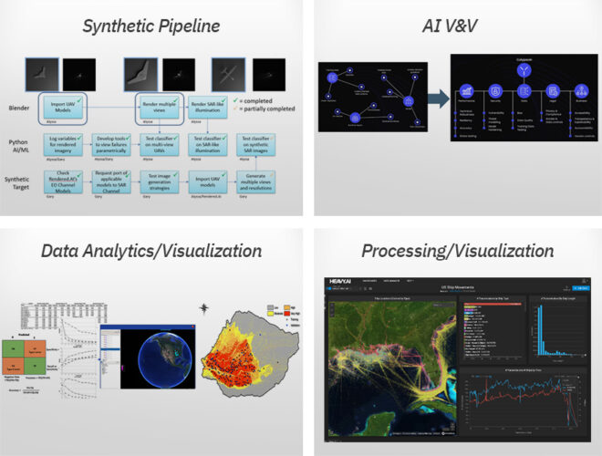
Commercial Experts: We offer our commercial experience, data scientists, and phenomenology experts to support efforts using the CIC to perform commercial utility assessments, new sensor development, synthetic data V&V, data value/usability studies, and more.
Products and Services: We offer access to CIC-based products and services such as synthetic data generation, data tagging, AI/ML V&V, data compression, data geo-registration, and more.
Work With the Commercial Innovation Center
Press Inquiries About the CIC
Commercial Innovation in the News
- Commercial Imagery
- Satellite Launches
- EO-MSI
- SAR
- HSI
- RF
- SSA
Commercial Imagery
Finland developing device to counter alleged Russian satellite jamming | - Macau Business
The interference, believed to be from Russia, has also disrupted satellite imagery used by Finland's military, border guard service and its forestry ...
Satellite imagery helps coastal data collection - Spatial Source
A new study highlights the accuracy of optical satellite-derived bathymetric datasets in a shallow, low-wave-energy coastal environment.
Emory developing new approach to control dangerous urban mosquito in Ethiopia
Xiao Huang, Emory assistant professor in environmental sciences and an expert in AI, remote sensing and satellite-image processing, is co-principal ...
Not to be alarmist, but is there any credence to that satellite pic of CECOT in El Salvador ... - Threads
Fun fact, if you type the name into Google Maps, it will now redirect you to your current location instead of showing you the satellite image. I was ...
Signs of the Season in Pine Island Bay - NASA Earth Observatory
The MODIS (Moderate Resolution Imaging Spectroradiometer) on NASA's Terra satellite captured this image of new ice forming atop the Amundsen Sea in ...
OSINTWarfare on X: "The latest satellite imagery shows a notable change in the deployment ...
The latest satellite imagery shows a notable change in the deployment of the Bavar 373-II Long-Range Surface-to-Air Missile (SAM) System.
60 Years Ago First Satellite Image of Earth - Kennedy Space Center Visitor Complex
On August 7, 1959, the Explorer 6 satellite launched atop a Thor-Able rocket from Cape Canaveral, Florida. Its mission was to study Earth's ...
Satellite Imagery Shows Sandstorm Crossing Iraq | Herald Sun
Satellite imagery shows a sandstorm blowing through Iraq on Monday, April 14. The Cooperative Institute for Research in the Atmosphere (CIRA) ...
AI-powered algorithm enhances satellite monitoring of air pollution - Phys.org
... satellite. Mar 25, 2024. Satellite data and multispectral imagery advance glacier lake depth measurement. Feb 13, 2025. Long-term measurements reveal ...
Satellite Imagery Shows Sandstorm Crossing Iraq - Yahoo News UK
Satellite imagery shows a sandstorm blowing through Iraq on Monday, April 14.The Cooperative Institute for Research in the Atmosphere (CIRA) ...
Satellite Rooftop Bar | Tax Day calls for a proper drink (or two). Join us for Pressure Drops all ...
Log in. Open app. satellitebarchs's profile picture · satellitebarchs. •. Follow. Photo by Satellite Rooftop Bar on April 15, 2025. May be an image of.
Military strikes are unlikely to permanently destroy Iran's nuclear program
... This satellite image released and taken on April 2, 2025 by Planet ...
Artificial Intelligence Techniques for Landslides Prediction Using Satellite Imagery - IJIRT
Machine learning (ML) algorithms are increasingly being used for automatic landslide prediction and detection, especially using satellite images.
Rivada CEO Declan Ganley: 'Now People are Listening' and Want Optionality in Connectivity
Share. Rivada Space Networks CEO Declan Ganley on a panel during SATELLITE 2025. Photo: Steven David for Access Intelligence ... to invest in satellite ...
Mystery 'mound' spotted at El Salvador prison sparks conspiracy theories - Metro
Concerns have been raised after satellite images revealed a large dirt mound on the grounds of a brutal El Salvadorian prison.
How brutal capture of Sudan refugee camp played out | World News
Available footage and satellite images show the RSF's capture of Zamzam was closely followed by fires being lit across the camp. visualization. In one ...
White House freezes funding for Harvard after it defies demands - YouTube
Comments1.2K. thumbnail-image. Add a comment... 10:59 ... Satellite Images Reveal The Reality Of Saudi Arabia's $2 Trillion Megacity In The Desert.
Contaminated Hartford scrapyard gets $5.4M in state borrowing for cleanup, remediation
(Image courtesy Google Earth). Image courtesy Google Earth. A ...
Up to 15 Greek satellites set for launch within two years | eKathimerini.com
... satellite imagery to assess crop coverage in Thessaly. Later, the same image might be purchased again by the Ministry of Environment, through the ...
Here's how a satellite ended up as a ghostly apparition on Google Earth - Ars Technica
Google Earth data indicates that the image was taken on November 30, 2024, by a high-resolution Pleiades observation satellite owned by Airbus.
Satellite Launches
Firefly Aerospace's Firefly Alpha to launch Lockheed Martin's FLTA006 Message in a ... - SatNews
The satellite bus is customizable to support different missions, including remote sensing, communications, imagery and radar Earth observations.
ULA's launch of Amazon Project Kuiper now is YTBD - SatNews
This image has an empty alt attribute; its file name is Amazon-6-. Amazon hasn't said how many satellites it plans to launch on the Kuiper-1 ...
Hampshire Wedding Photography Website Launch - CBS 4
The launch reflects a commitment to showcasing the natural beauty and emotional essence of Hampshire weddings through timeless images, perfectly ...
'T-minus five, four, three, two…': MSU's CubeSat launches weather balloon - The Reflector
... imaging systems designed to detect ... The team plans to submit the satellite to NASA's Educational Launch of Nanosatellites CubeSat Launch ...
SpaceX Falcon 9 rocket launches 27 Starlink satellites to orbit on record-breaking 27th flight (photos)
SpaceX Falcon 9 rocket launches 27 Starlink satellites to orbit on record-breaking 27th flight (photos). Story by Mike Wall. • 1d.
Hampshire Wedding Photography Website Launch - Fox 59
Jordan Fox Photography, known for its expertise in documenting love stories with stunning wedding photographs, has created this satellite site to ...
D-Orbit sets course to expand beyond space transportation services
“Those satellites, especially CubeSats, would have needed a lot of propulsion to go where they needed to go. For instance, SpaceX launches go [to] SSO ...
AT&T appears to have delayed the launch of its satellite service - PhoneArena
... satellite program. newsletter-background-image. Receive the latest AT&T news. By subscribing you agree to our terms and conditions and privacy ...
Overland AI launches ULTRA autonomous ground systems for defense - The Robot Report
... satellite uplinks. “ULTRA gives commanders an immediately ... hero image of a BRINC drone and autonomous launch pod. BRINC raises $75 ...
AI-powered algorithm enhances satellite monitoring of air pollution - Phys.org
Satellite data and multispectral imagery advance glacier lake depth ... Scientists propose aerosol retrieval method for newly launched satellite.
Military strikes are unlikely to permanently destroy Iran's nuclear program
... This satellite image released and taken on April 2, 2025 by Planet ...
Australia Casts Doubt On Russia Basing Bombers At Indonesian Air Base - The War Zone
An overview satellite image of Indonesia's Manuhua Air Force Base and Frans Kaisiepo Airport. · A closer view of aircraft hangars at Indonesia's ...
Swamped Skies - Kottke
Swamped Skies. a photo of a night sky with dozens of satellite trails ... launch over 40,000 satellites in total. The space industry is almost ...
Copernicus Sentinel-6 and Sentinel-3 Next Generation Topography System and Operations Manager
High Speed Imaging ... liaising with other project sections to ensure a consistent approach to satellite procurement, verification, launch and in-orbit ...
Strengthening Australia's space cooperation with South Korea | The Strategist
With ImagesWithout Images. The time is ripe for Australia and South ... satellite development and responsive launch also contribute to. Lee's ...
First Black Woman in Space Schools CBS News Anchor - Men's Journal
... launches from Launch ... satellites was launched and the satellites have entered the preset orbits. (Photo by Du Xinxin/Xinhua via Getty Images).
Polish space company signs whopping €52 million contract with European Space Agency
... satellite construction and launch. The contract is scheduled to run from April this year until December 2027. #POLAND#SPACE. SHARE ON FACEBOOK ...
Europe must choose between US or Chinese satellite tech, says FCC chair | The Verge
Image: Cath Virginia / The Verge, Getty Images. Jess ... launched 15,000 satellites by 2030, placing it in a better position ...
NASA's Lucy Spacecraft Prepares Second Asteroid Encounter - Space Daily
All three science instruments - the high-resolution greyscale imager called L'LORRI, the color imager ... Amazon satellite launch scrubbed due to ...
SpaceX, ULA rocket launches from Vandenberg, California, may be visible in Arizona, too
An evening launch of a SpaceX Falcon 9 rocket carrying 20 Starlink V2 Mini satellites, from Space Launch Complex at Vandenberg Space Force Base is ...
EO-MSI
Satellite imagery helps coastal data collection - Spatial Source
The results revealed an optimised method, achieving the best results with input spectral bands from the low-cost PlanetScope SuperDove constellation.
Sir David Berriman, pioneer of satellite TV who later spoke up for loss-hit Lloyd's Names
Sir David Berriman, financier who pioneered satellite television and spoke up for loss-hit Lloyd's Names ... 'You say you care about Mother Earth? I'm ...
Up to 400000 displaced from Darfur camp after Sudan RSF takeover, UN agency says
Satellite imagery from Maxar Technologies showed burning buildings and smoke in Zamzam on Friday, echoing prior RSF attacks.
Ukraine's 2024 strike on Russian arsenal near Rostov destroyed 90% of it
... Tikhoretsk ammo depot, with destroyed facilities ... satellite imagery analysis. Exactly one year later, on Sept. 21 ...
Maxar Technologies
Maxar Technologies · @Maxar. Our very high-resolution satellite imagery can help mining companies make informed decisions, reduce environmental ...
How brutal capture of Sudan refugee camp played out | World News
Satellite images form Maxar confirm buildings burned across the south of the camp on April 11, close to where fighters were seen. On Tuesday, the ...
Form 424B5 Satellogic Inc. - StreetInsider
Our strategy is focused along three distinct business lines: Asset Monitoring, Constellation as a Service (“CaaS”), and Space Systems. These business ...
Satellogic Down After Stock-Sale News, Monday Increase - MarketWatch
Last week, Satellogic said it was awarded a multiyear $30 million contract to provide analytics from its constellation to a defense and security ...
Google Maps User Spots Mysterious Satellite Racing Over Texas, Possibly a Starlink Craft
It's a major mystery, and we'd love to see what the giants in this industry have to say, including Google, Maxar Intelligence, and of course, Airbus.
Australia Casts Doubt On Russia Basing Bombers At Indonesian Air Base - The War Zone
An overview satellite image of Indonesia's Manuhua Air Force Base and Frans Kaisiepo Airport. (Satellite image ©2025 Maxar Technologies) A closer ...
in Addition to Alabuga, Shahed Drones Now Produced at IEMZ Kupol | Defense Express
... Satellite image: Maxar / Credit: IISS. Earlier, Defense Express reported that russia would open a Tu-95MS pilot school, despite no longer producing ...
26/11: Evasive Tahawwur Rana ducking NIA questions on finances, ISI - Yes Punjab News
... (ISI), investigators said on Monday. During his over 10-hour grilling ... He allegedly used Satellite geotagging to identify targets and ...
Class Action Filed Against Constellation Brands, Inc. (STZ) Seeking Recovery for Investors
... Legion FC. 2 days ago. Video · Marketplace · Epic Deals · Find a Job · Living ... Constellation Brands, Inc. (NYSE:STZ) investment and want to learn ...
Class Action Filed Against Constellation Brands, Inc. (STZ) Seeking Recovery for Investors
... Legion · San Diego Mojo · Youth Baseball · PPR · Game of the Week · This Week's ... Constellation Brands, Inc. (NYSE:STZ) investment and want to learn ...
North Korea is making what could be its largest, most advanced warship ever, new satellite ...
... satellite photos show. Photo: Maxar Technologies via CNN Newsource. By Brad Lendon and Gawon Bae, CNN. New satellite images show what could be North ...
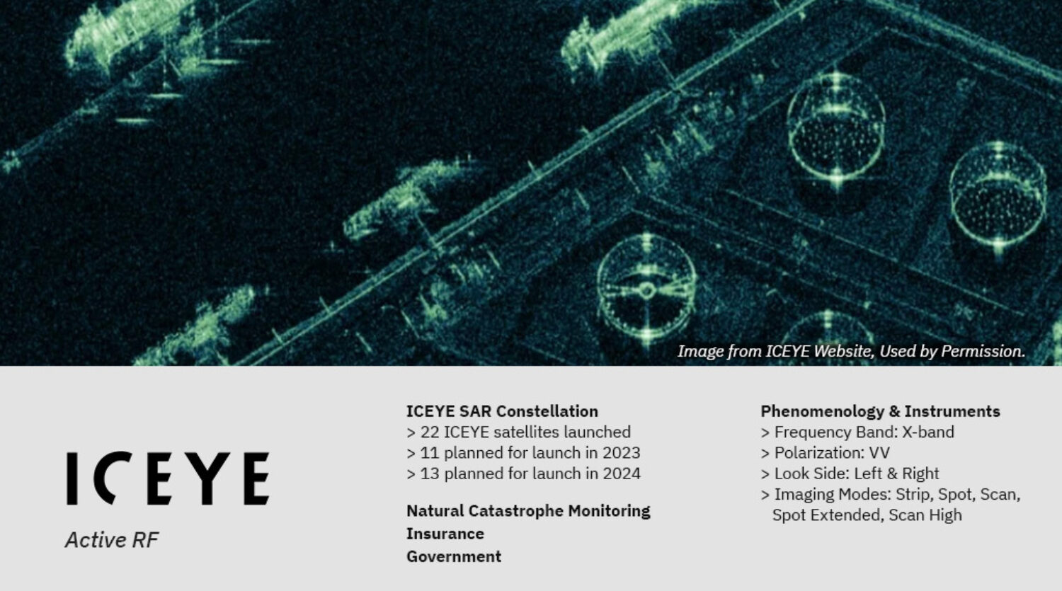
NASA CSDA Program Vendor Focus—ICEYE US
Worldview · Fire Information for Resource Management System (FIRMS) ... ICEYE satellite in orbit over an erupting volcano. Image Caption. ICEYE ...
Chief Meteorologist Anthony Yanez and the mysterious case of the strange-looking clouds
We started by going to a NASA satellite worldview. This is what we discovered for April 11 and the matching times. I've underlined the city, Ponta ...
Inside North Korea's vast operation to help Russia's war on Ukraine - Reuters
Satellite image: Maxar Technologies. Kursk. With superior troop numbers and newly replenished ammunition, Russia made slow but steady territorial ...
Satellogic: U.S. Domestication Is Bullish But Capitalizing On Constellation Is Key (SATL)
The US domestication and partnership with Maxar could significantly boost Satellogic's growth and attract more investors.
Chilling satellite images show North Korea building massive and 'most advanced' warship ever -
Images captured by satellite company Maxar Technologies and Planet Labs have revealed North Korea is building a new warship.
SAR
Eos Energy (EOSE) Appoints Joseph Nigro to Board, Enhancing Lead - GuruFocus
Eos Energy Enterprises, Inc. (EOSE) recently appointed Joseph Nigro, a former CFO of Exelon and CEO of Constellation Energy, to its Board of Directors ...
Turkey-Syria temblors reveal missing piece in earthquake physics - Phys.org
Luo and team used interferometric synthetic aperture radar on imagery collected by the Sentinel-1 satellite and Advanced Land Observing Satellite ...
Trump envoy says verification 'key point' in Iran talks - Space War News
Beyond Gravity and Rocket Lab join forces to streamline satellite constellation ... Umbra joins STRATFI initiative to build advanced defense satellite ...
NASA CSDA Program Vendor Focus—ICEYE US
Learn more about the NASA Commercial Satellite Data Acquisition (CSDA) program vendor ICEYE US and how to discover, access, and work with ICEYE's ...
EXCLUSIVE: European Space Agency eyes defence in big budget boost - Euractiv
A number of EU companies, including Finland-based ICEYE, which provides commercial satellite services to Ukraine, have called for such a programme to ...
Türkiye-Syria Temblors Reveal Missing Piece in Earthquake Physics - Eos.org
Share this: ... A satellite image of the border between Türkiye and Syria is marked with multicolored waves. An interferogram shows evidence of ground ...
First Global Comparison of Glacier Mass Change: They're All Melting, and Fast - Eos.org
Zemp hopes to focus future work on assessing how glacier melt affects seasonal runoff, and that requires ongoing access to satellite data and higher- ...
Umbra joins STRATFI initiative to build advanced defense satellite network
Umbra intends to use the funding to design and deploy a new generation of satellites engineered to deliver expansive SAR coverage for maritime and ...
Top Trump official asks Europe to choose between US or Chinese tech - Cryptopolitan
Eos Coin · Ethereum · Litecoin · MATIC · Monero · Near Protocol · Notcoin ... “If Europe has its own satellite constellation, then great, I think the ...
Northrop Grumman, Intelsat complete historic satellite life-extension mission
“The MEV mission proved that in-orbit servicing enhances satellite ... Nato's Situation Center turns to ICEYE for SAR Satellite Data · Argotec ...
HSI
RF
Rivada CEO Declan Ganley: 'Now People are Listening' and Want Optionality in Connectivity
The Dawn of a New Era in Satellite IoT – ORBCOMM · Moving Communications ... Rivada is ramping up activity to build the 600-satellite Outernet ...
ORBCOMM® launches SKYWAVE™ Connect partner program to - GlobeNewswire
The SKYWAVE Connect partner program provides access to ORBCOMM's IoT devices, multi-mode satellite and cellular connectivity services, development ...
United States : Storms on the horizon for Pentagon's satellite weather forecasters
The US Defense Meteorological Satellite Programme is behind schedule and the US Space ... space weather contracts with GeoOptics, Spire and PlanetIQ, as ...
Umbra joins STRATFI initiative to build advanced defense satellite network
The constellation will support tip-and-cue tasking capabilities for U.S. ... Unseenlabs opens Singapore office to boost Asia Pacific operations.
3 Reasons to Buy Fubo Stock Like There's No Tomorrow - The Globe and Mail
... satellite television platform with enhanced ... For Dave Roscoe, ORBCOMM's President of Satellite IoT, SKYWAVE Connect benefits all parties.
Gilat Receives a Multimillion Order from a Global Defense Organization | The Manila Times
Gilat Satellite Networks Ltd. (NASDAQ: GILT, TASE: GILT) is a leading ... ORBCOMM® launches SKYWAVE™ Connect partner program to accelerate channel ...
Connecting the world: American Airlines to provide complimentary inflight Wi-Fi, sponsored by AT&T
... satellite connectivity, accounting for roughly 90% of its fleet. ... For Dave Roscoe, ORBCOMM's President of Satellite IoT, SKYWAVE Connect benefits all ...
ORBCOMM® launches SKYWAVE™ Connect partner program to accelerate channel partner growth
For Dave Roscoe, ORBCOMM's President of Satellite IoT, SKYWAVE Connect benefits all parties. “When our partners succeed, we succeed. SKYWAVE ...
New Tractor Autonomy Solution from Carbon Robotics Uses Starlink Connectivity
The Dawn of a New Era in Satellite IoT – ORBCOMM · Moving Communications ... The satellite link ensures that data from GPS, cameras, and radar ...