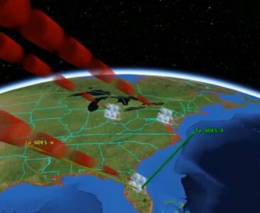
TerraSTAR IR Beacon Simulation
May 02, 2024
This simulation depicts a hypothetical portrayal of how TerraSTAR could be operated to direct its broadband energy toward different satellites consecutively.

In this simulation, TerraSTAR sites in Ohio, Virginia, and Florida can be seen directing their energy toward GOES-West in geostationary orbit before slewing over to point at JPSS-1 as it passes overhead. Once out of view, the TerraSTAR systems redirect toward GOES-East before again slewing over to another polar orbiter, this time JPSS-2. Pointing strategies are developed through the use of Riverside Research’s Collection Planning Suite (CPS) and will be uploaded to the TerraSTAR control system remotely on a routine basis.
Recent Insights
Nov 24, 2025
From the Lab to the Field: Intelligent Field Operations and Surveillance
Nov 13, 2025
Riverside Research’s Graphene Software Revolutionizes Data Management with AI-Assisted Graph Data Normalization
Oct 16, 2025
